Club members meet on Tuesdays and Thursdays to run at differing paces and distances of 5 to 6-ish miles or 6 to 8-ish miles. During lighter evenings we participate in off-road runs and use road routes in the winter months. For information on routes, see the rota below. Interval training takes place on most Tuesdays.
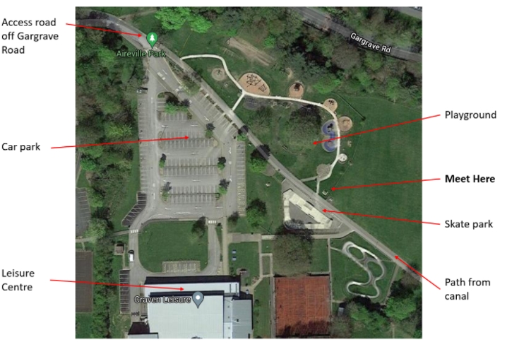
On Tuesdays & Thursdays, we meet at 7pm in Aireville Park at the picnic bench by the main path near the parkrun finish point (see map below).
On Wednesdays we have a social run which is off road. The Wednesday social runs start at a different location each week at 7pm. Please ask for the start place if you’d like to join us.
Email skiptonacseniors@gmail.com for further information about Senior running.
Summer Route Descriptions and Maps:
Route A Sharphaw –
- Sharp Haw ‘fork in the path’ – Park top entrance, roundabout, Stirton, up Bog Lane to small car park, forestry road to fork in the path and back across field to Bog Lane and return via Stirton – Route
- Sharp Haw ‘clearing’ – Park top entrance, roundabout, Stirton, up Bog Lane to small car park, forestry road doing the complete loop, back down Bog Lane and return via Stirton – Route
Route B Bradley –
- Skipton Moor – Bottom park entrance, canal to Bay Horse pub, up Skipton Rd towards Bradley, left at high point on paths to High Bradley, ascent to trig point, descent to top of Shortbank Rd, return direct via canal – Route
- High Bradley & Cawder – Bottom park entrance, canal to Bay Horse pub, up Skipton Rd towards Bradley, left at high point on paths to High Bradley, left across fields to Cawder & back along canal – Route
Route C Skipton Woods –
- Skipton Woods (slightly shorter than below) – Park bottom entrance, canal, Coach St, Skipton woods, golf course, right along Brackenley Lane, turn off right just before Embsay on footpath over to Skipton Rd, up to Manby Castle, through right side of quarry, down Bailey, up Gargrave Rd – Route
- Skipton Woods (slightly longer than above) – Park bottom entrance, canal, Coach St, Skipton woods, golf course, right down Brackenley Lane, Cavendish pub, track through left side of quarry, down the Bailey, up Gargrave Rd – Route
Route D Carleton
- Carleton fields & railway – Bottom park entrance, Canal to Sawley St, Ings Lane, paths across fields & Aire to top of Heslaker Lane, diagonally right across fields to railway line, right to Heslaker Lane, turn right back to Carleton, back across fields return via outward route – Route
Route E Thorlby
- Down the park, cross the canal, turn right and out to the Thorlby swing bridge. Cross the A65 and go through Thorlby to Stirton. Straight on over White Hills and then down Rockwood to the park – Route
- Shorter versions can be: Double back from wherever along the canal; Back down the main road after the swing Bridge: Turn right in Stirton and back past Robertshaws
Links to the Winter route options & maps (best viewed on a PC):
- Town circular (forwards & backwards)
- Longer 7.2 miles: http://www.gmap-pedometer.com/?r=2293833
- Medium 5.35 miles: http://www.gmap-pedometer.com/?r=4109817
- Central Town
- Longer 6.5 miles: http://www.gmap-pedometer.com/?r=2293871
- Medium 4.83 miles: http://www.gmap-pedometer.com/?r=4109831
- Embsay / Eastby
- Longer ‘last light’: 8.25: http://www.gmap-pedometer.com/?r=2293850
- Medium ‘Embsay Loop’: 6.55: http://www.gmap-pedometer.com/?r=2303704
- North-East town
- Longer 7.3 miles: as medium plus Embsay loop
- Medium 5.8 miles: http://www.gmap-pedometer.com/?r=4109571
Coaches


